At Hind Aerospace, we deliver professional drone survey services across Tamil Nadu, supporting industries and government projects with accurate mapping and data-driven insights. Our UAV-based solutions help accelerate project timelines while reducing overall costs and dependency on traditional surveying methods.

By utilizing advanced drone systems and GIS-enabled technologies, we capture high-resolution aerial data and transform it into detailed maps, 3D models, and meaningful analytical outputs. Our expertise covers a wide range of sectors including land surveying, infrastructure development, mining, agriculture, and construction monitoring.

With a strong emphasis on precision, efficiency, and regulatory compliance, Hind Aerospace is dedicated to supporting the infrastructure growth and development requirements of Tamil Nadu through reliable and modern drone-based solutions.

UAV Drone Survey and Aerial Mapping Solutions across Tamil Nadu, providing advanced geospatial services such as high-resolution aerial imaging, accurate photogrammetry-based mapping, LiDAR-supported surveying, multispectral data analysis, efficient drone data processing, detailed site inspections, and solar PV plant monitoring.

At Hind Aerospace, we provide cutting-edge UAV drone survey and aerial mapping solutions across Tamil Nadu, helping industries gain access to accurate geospatial intelligence for smarter project execution. By combining advanced drone platforms with modern surveying methodologies, we enable businesses to collect reliable aerial data that enhances planning, improves monitoring, and accelerates decision-making.

Our expertise covers high-resolution photogrammetry, LiDAR-based surveying, and multispectral imaging, delivering precise terrain data and detailed surface analysis even in challenging environments. These solutions support a wide range of applications, from infrastructure development and mining operations to agricultural monitoring and environmental assessment.

Beyond surveying, we offer aerial inspection services, professional drone videography, and complete drone data processing, transforming raw aerial captures into actionable deliverables such as orthomosaic maps, 3D models, and GIS-ready datasets. These outputs help organizations streamline operations and improve project accuracy.

We also specialize in solar PV drone inspections, enabling efficient fault detection, performance evaluation, and preventive maintenance planning for solar energy assets.

Driven by innovation, operational safety, and precision-focused workflows, Hind Aerospace delivers dependable drone-powered solutions for industries such as infrastructure, construction, energy, mining, and agriculture throughout Tamil Nadu, empowering clients with data-driven insights for better results.

UAV Survey & Mapping Team in Tamil Nadu

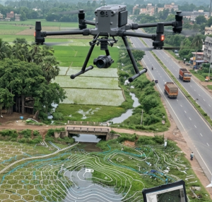
At Hind Aerospace, our dedicated drone survey and mapping team delivers professional UAV solutions across Tamil Nadu, helping industries achieve accurate, reliable, and efficient geospatial data collection. We specialize in aerial surveying, mapping, and inspection services tailored to meet the unique demands of each project.

By combining field expertise with advanced drone technology, our team ensures smooth on-site operations while capturing precise aerial data for detailed analysis. This enables improved planning, enhanced site visibility, and faster decision-making for projects in infrastructure, construction, agriculture, and land development.

With a commitment to accuracy, operational safety, and modern surveying methods, we transform complex project environments into meaningful insights that drive better outcomes. Hind Aerospace continues to support organizations across Tamil Nadu with dependable drone solutions that improve efficiency and maximize project value.

Drone Survey & Inspection Solutions in Tamil Nadu

Hind Aerospace delivers dependable drone survey and inspection services across Tamil Nadu, providing high-precision aerial data for a wide range of project needs. By utilizing advanced UAV technology, we assist industries in capturing accurate and reliable information for infrastructure development, construction monitoring, agriculture, and industrial operations.

Our on-field team ensures smooth execution at project sites while converting complex aerial datasets into clear and actionable insights. This enables clients to improve planning efficiency, monitor progress effectively, and achieve faster project completion.

With a strong commitment to precision, safety standards, and consistent quality, Hind Aerospace offers trusted drone solutions that support smarter decision-making and better project outcomes across Tamil Nadu.

Leave a Reply

Your email address will not be published. Required fields are marked *